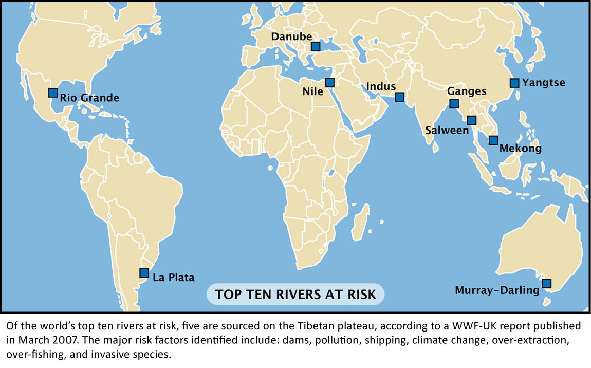
Rivers at Risk: Stealing Water
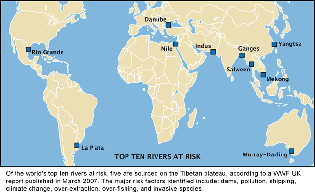
Tibet's mighty rivers supply fresh water to more than a third of the planet's population.
- Which major rivers of Asia are sourced in Tibet?
- Which headwaters of major rivers are sourced in Tibet?
- What pollution threats to these rivers are posed from within Tibet?
- Currently, some rivers of the Tibetan plateau are running at high flow. Why?
- What is the plan for diverting water from the Yangtse headwaters to Yellow River headwaters? What on earth are China's engineers getting up to?
- How much can an ecosystem take before it collapses?
"The world is facing a massive freshwater crisis, which has the potential to be every bit as devastating as climate change. We need business leaders and governments to recognise that climate change is not the only urgent environmental issue that needs to be dealt with, and that they need to take notice of this freshwater emergency and act now, not later."
—Dr David Tickner, head of the freshwater programme at WWF-UK
STEALING RIVERS
(click to enlarge)
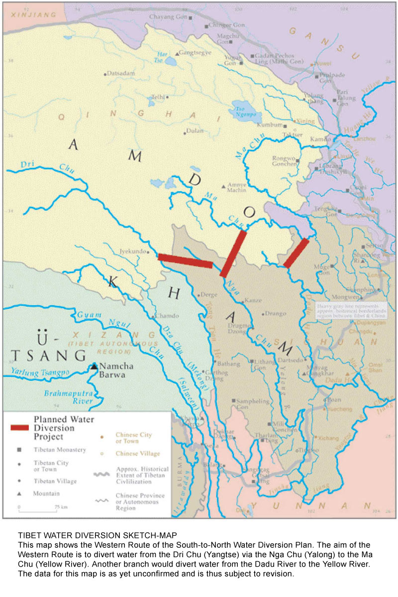
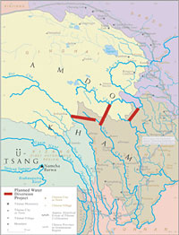
On the drawing board, at the edge of the Tibetan Plateau, is a massive water diversion project. The Western sector of the South-to-North Water Diversion Scheme involves the building of three mega-dams (with wall heights of 175 metres, 302 metres and 292 metres) and a system of tunnels stretching some 300 kilometres. This would be designed to divert water uphill from the Yangtse river headwaters to the Yellow River headwaters.
The Western Route actually comprises several routes, taking water from the Yalung, Dadu and upper Yangtse rivers (in Qinghai and Sichuan) across mountains and directing it into the Yellow River. Which would then carry it across North China. Work on this route is in planning stages. The project may take 30 years or more to complete.
A water diversion project of this magnitude has never before been attempted in recorded history. It qualifies as the largest hydro project ever undertaken. What are the possible consequences of such a colossal hydro project? What is the fallout from stealing a river like this?
If you've never heard of this Tibet Water Diversion project, you have lots of company. There are over a billion Chinese who are completely in the dark about it too. Seems like Chinese authorities and the engineering planners have neglected to give any specific details to the media.
Enormous Implications
Here's a quote from expert Kenneth Pomeranz, from the University of California (writing in Asia-Pacific Journal, July 2009) on this planned massive water diversion project:
"The western route poses by far the biggest complications. It is here that the engineering challenges are most complex and the solutions most untested. It is here (and nearby Yunnan) that the needs of agrarian and industrial China collide most directly with the lives of Tibetans, Yi, Miao, and other minority groups. It is here that the environmental risks of dam building become major international issues, with enormous implications for the Mekong, Salween, Brahmaputra and other rivers relied on by hundreds of millions of South and Southeast Asians. And it is here that major water projects—which always include many uncertainties—collide with what has always been an extraordinarily fragile environment, and one which now faces far more than the average amount of uncertainty from climate change: Tibet, home to by far the largest number of glaciers outside the two polar regions, is expected to warm at twice the global rate during the 21st century."
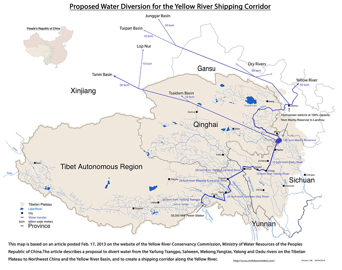
Water diversion for Tsangpo, Mekong and Salween rivers?
In February 2013, a startling new feasibility plan appeared on an official website, detailing the diversion of significant flows of water from the Tsangpo, Mekong and Salween rivers. That's in addition to the diversion of water from the Yangtse, Yalong and Dadu rivers (as outlined in the Western Route above). The waters would be diverted northwards toward the Yellow River, but with new variations. Under this proposal, large amounts of water would be diverted to the heavy mining/industrial area of the Tsaidam Basin, and to irrigate parched areas of the northwest like Turpan Basin.
The map below has been specially drawn for Meltdown in Tibet, based on the information available from the Chinese official website:

Diverting the Indus & Sutlej Rivers North?
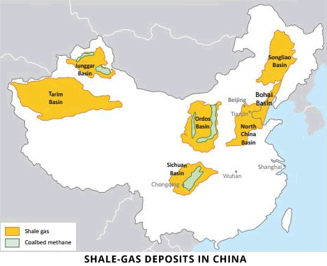
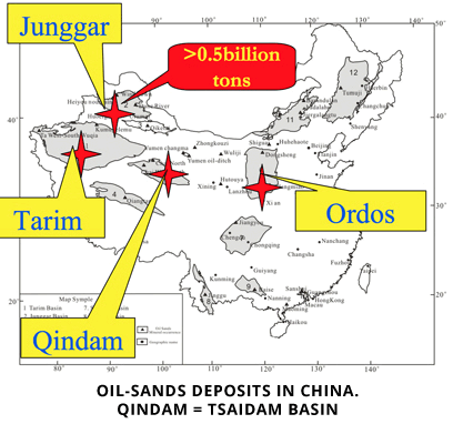
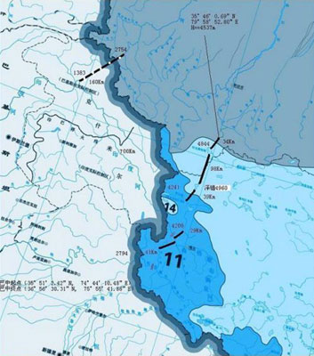
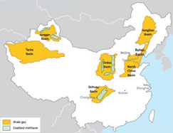
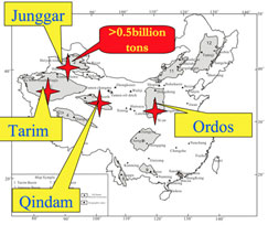
Chinese engineers are discussing the feasibility of diversion of water from the Indus and Sutlej Rivers in far-west Tibet northward to Xinjiang. The reasons for doing so are not stated, but most likely to do with mining in these areas. There are significant deposits of shale-gas and oil-sands in the Tarim and Junggar Basins in Xinjiang, and large deposits of oil-sands in the Tsaidam (Qindam) Basin in NW Qinghai Province. Extraction of shale-gas (by fracking) and extraction of oil from oil-sands requires huge quantities of water. In addition, massive amounts of water will be needed for new coking mega-plants being constructed in Xinjiang, which are slated to turn coal into gas and pipe that back to the east coast. There is a dam on the Indus River within Tibet. One small problem: the Indus River is the lifeline of Pakistan — the nation is totally dependent on the flow of this river. The following map, taken from Chinese website discussing the possible diversion, shows actual diversion routes planned.
east-west water diversion scheme
Meanwhile, on the east coast, another harebrained scheme to move seawater west, to the parched desert terrain of Xinjiang. This proposal aims to hydrate Xinjiang by pumping seawater 2,000 kilometres inland and 1,200 metres uphill from the Bohai Sea. Massive water desalination plants are also planned on China's east coast:
The summit's basic ideas on the subject of "Moving Seawater West; Bringing Bohai to Xinjiang" were as follows: At the northwest shore of the Bohai Sea, raise the seawater to a height of 1,200 metres above sea level and send it to the southeast part of Inner Mongolia Autonomous Region. From there, skirt the foothills of the Mazong mountains and enter Xinjiang. The tentative plan is intended to fill salt flats, saltwater lakes, and structural basins with large quantities of seawater to form man-made seawater rivers and lakes, thereby suppressing the desert. At the same time, a large quantity of seawater will naturally evaporate under the abundant sunlight of the northwest, becoming moist air that will humidify the northern climate and provide a source of increased rainfall, thereby achieving the goals of controlling the country's deserts and dust storms and completely transforming the poor ecological environment of the northern and western regions.
—source: Chinadigitaltimes.net
>> Next: Valleys of the Dammed